500/6 Bizpoint 10
Canal Rd, Maehia, Chiang Mai 50100
Ph : 093-698-4884
Email : reception@chiangmaidoctor.com
Climate factors in Chiang Mai and Northern Thailand
This webpage is a short explanation of the climate in Chiang Mai and Northern Thailand. It explains its different features, the regional causes for seasonal changes and other factors
Go directly to:
Other information about weather
Other information about flooding
Other information about air pollution
Northern Thailand is situated in the tropics with the Tropic of Cancer situated around 450 km north of Chiang Mai, half way to Kunming in China. While many regions situated at this latitude are typically the dry hot tropics such as the Sahara and Arabian deserts (but also Atacama, Kalahari, Namib and Australian deserts in the southern hemisphere), South East Asia, along with the Indian peninsula benefits of a milder climate. It is typically characterised by a 6 month alternation of wet and dry spells with a broadly warm to hot weather marked by a dry and a rainy season.
In the Köppen climate classification, Northern Thailand is mostly ‘Aw’, which corresponds to tropical savannah and is also found in central India, Northern Australia, a large part of the tropical sub-saharan Africa, the southern part of Mexico and large parts of Brazil. While other Aw climates are closer to the equator, the relative proximity of the ocean on both sides of South East Asia, and the monsoonal system are part of the reason why a more humid climate is possible in Northern Thailand (but also the rest of non-peninsular Thailand, Cambodia, Laos, and some parts of Myanmar).

Figure.1 World map and details of South and South East Asia climates following the Köppen classification. Light blue is ‘Aw’ which is tropical savanna, typically characterised by hot weather with humid and dry seasons. CM: Chiang Mai.
Broad Climate description
The Northern Thailand climate is characterised by 3 meteorological seasons. A cold season during the northern hemisphere winter months, mildly dry; and switching to a hot dry season in spring, then transitioning over a month or two into the rainy season in the middle of the year. The main factors controlling the climate in continental South-East Asia are the two oceanic masses (Pacific & Indian), the Himalaya & associated mountain ranges and the changes in the distribution of (continental) high pressure and low pressure systems developing from oceanic domains.
The rainy season is typically defined as starting in May and last to Mid-October. It is based on the prevailing winds of the South-West Monsoon bringing moisture from the Indian Ocean and the South China Sea. The regional weather during the rainy season is therefore heavily influenced by the Indian and East Asia monsoon. The start of the rainy season is more controlled by a change in dominant winds than the ground observation of precipitation.
The cold season is from Mid-October to Mid February and is characterised by a drier North-East monsoon with some moisture brought from the South China Sea. Although October-November is more transitional with the rainy season, it can occasionally get cold (by tropical standards) in December and January due to cold surges from Northern China. Humidity and rain in those months can also be attributed to this winter monsoon.
The hot season from Mid-February to Mid-May is in pre-monsoon conditions. Prevailing winds are relatively mild and the influence of continental high pressure systems leaves a dry and hot atmosphere during that period over Northern Thailand. This atmospheric pattern progressively develosp into more humid conditions as it gets closer to the rainy season.

Figure 2. Map of East Asia during the cold, hot and rainy season of South-East Asia. Cold season has winds flowing south, away from the Siberian high pressure and can bring cold weather as far south as Northern Thailand. Hot season is influenced by the Tibetan high pressure system, eventually taken over by the Indian monsoon and western Pacific winds during the rainy season.
Regional factors that influence the climate and weather in Northern Thailand
The annual climate features in Northern Thailand are characterized by typical tropical climate with contrasted seasons that are linked to atmospheric movements between the equator and higher latitudes. A few atmospheric features and land characteristics play a role, interact with each other, giving a complex picture explaining the general change in weather and some extreme events in Northern Thailand.
The Intertropical Convergent Zone
One of the most important factor is the Intertropical Convergent Zone (ITCZ), which position itself over South East Asia and dictates when the rainy season starts and ends. The ITCZ is a zone more or less parallel to the equator where northeast and southeast trade winds converge and follows the thermal equator (the zone with the highest mean temperature for a given time of the year). As such, it will shift from the southern hemisphere summer (Dec-Mar) to the northern hemisphere summer (Jun-Sep) every year.
In the Northern hemisphere, as the southerlies cross the equator, the Coriolis effect tends to modify their direction into westerlies, that converge with northern hemisphere easterlies, causing significant atmospheric convection. Warm, moist air carried from the oceans interacts with the colder, drier continental northern winds and are more likely to form tropical storms. This convergence between SW and NE winds is typically called the Monsoon trough. The ITCZ is particularly visible in oceanic environment while over continental areas, it is affected by other features and as a result, the most rainy areas might not coincide with the position of the ITCZ.

Figure 3. World map with the maximum extend of the ITCZ in northern and southern hemisphere summers.
Monsoon
Monsoons are dominant winds that affect the tropics and particularly known for their role in the rainy season. However, their seasonal reversal means that monsoons can also occur at other times.
The Indian summer monsoon heavily affects India and Myanmar during the rainy season under the influence of the southern monsoon. The monsoon winds, charged with humidity, progress through the subcontinent, bringing frequent rains. By the end of May, the Indian Monsoon has reached Northern Thailand but significant mountain belts in Myanmar limits its impact. Further north, the Indian monsoon is stopped by the Himalaya and Hengduan mountains. The Indian summer monsoon typically loses its intensity in mid-October as the ITCZ retreats to Southern Thailand.
The Indian winter monsoon is less consequential and is produced by the high pressure continental system flowing southeast and producing mostly dry conditions.

Figure 4. Summer monsoons in South East Asia is under the influence of the Indian monsoon, from the South-West and the East Asian monsoon with a general South-East direction at high latitudes. Both monsoon flows converge over South East Asia. The winter monsoon is emanating from the pressure high over Siberia and eventually Tibet, producing a North-South dry flow occasionally charged with humidity over the South China Sea.
The East Asia monsoon is an atmospheric flow that carries moist air from the Pacific Ocean into Eastern Asia. While the Indian monsoon alone has a significant but limited impact in Northern Thailand, the arrival of the East Asia monsoon in June generally marks meteorological conditions that are constantly humid. The East Asia monsoon extends far inland into central and even Northern China, pushed by a strongly developed Hadley cell that brings warm, humid air from the equatorial region to higher altitudes and northward, causing the typical precipitations associated with the tropical rainy season sometimes as north as Mandchuria.
The East Asia winter monsoon, like its Indian counterpart, is produced by the Siberian high pressure system. While most of the winds produced generate dry weather, a branch bringing air masses over the South China sea can gather sufficient humidity to produce significant winter precipitations over Southern China, Vietnam and equatorial South East Asia and providing less dry conditions in continental South East Asia in general.

Figure 5. Precipitation map of continental South East Asia during the winter monsoon. Significant rains are seen on the Vietnamese coast, the Malay peninsula, southern China and not so dry conditions elsewhere in South East Asia (modified from Sooktawee et al., 2014).
High pressures
In October, high pressure centres appear over Siberia and China and bring cold southerly winds to the continent with occasional cold weather in December-January in Northern Thailand. This continental high pressure system also flow towards the South China Sea suppressing the north-east summer monsoon although cyclones can still reach the region.
Progressively during spring, the Tibetan high pressure system grows in strength and bring the pre-monsoon conditions to Northern Thailand with hot, dry weather and dominant winds from the west. As the rainy season approaches, the Tibetan high expands into the South Asia High (SAH), a large anticyclonic circulation producing significant heat waves in South East Asia.
During the rainy season, continental high pressure systems have a lesser importance and the Western Pacific Subtropical High (WPSH) moves northward from its position around the Philippines-Micronesia to Okinawa-Izu-Bonin latitudes. In some cases, the SAH can develop eastward and merge with the WPSH.

Figure 6. Maps of East Asia during the cold and rainy season showing the distributions of pressure systems (values in mbar). Green lines and arrows show the position and direction of jet streams during those periods.
Low Pressures
During boreal winter, low pressure systems are mostly equatorial (to the Timor Sea, Arafura Sea) or in the North Pacific. Their positions affect how air flow from continental high pressure systems.
Starting around May and persisting until October, the Asiatic Low, centered over India and the Bay of Bengal, plays a major role in the monsoon affecting South and South-East Asia. It is part of the ITCZ which is recognizable on isobaric weather maps as a series of low pressure centres extending eastward.
Jet Streams
During the rainy season, the tropical Easterly Jet stream that flows from South East Asia to the horn of Africa at around 12-15 km altitude and 140 km/h plays a role in the distribution of rains during the summer monsoon. The shear winds present in this jet stream also play a significant role in weakening cyclones produced by the Bay of Bengal.
The East Asian Subtropical Jet Stream (EASJ) is an eastward flow that reaches its maximum velocity of 250 km/h at around 10 kilometers altitude in winter for low latitudes. Like its south Asian counterpart, it plays a role in the distribution of precipitations, temperatures, droughts and floods. It switches from the south of the Himalaya to the northern edge of the Tibetan plateau during Thailand’s hot season.
Seas & Oceans
The South China Sea between Vietnam and the Philippines plays a major role during the rainy season as a source of moist air. Although not producing the dominant monsoon winds in Northern Thailand, cyclones formed into the Pacific Ocean reached the Philippines region and are often further intensified as they cross the South China Sea to landfall on the Vietnam coast and South China. Many of these tropical depressions follow the ITCZ to cross Thailand a couple of days later. In winter, the South China sea remains a source of moisture for the winter monsoon.
The Bay of Bengal is the other significant body of water where the warm waters produce the main drive for the wet summer monsoon. The Bay of Bengal generates many cyclones during the summer but many move towards the Indian subcontinent and a minority go north into Bangladesh and Western Myanmar.

Figure 7. Topographic map of South East Asia showing the main mountain ranges, oceans and seas surrounding the peninsula.
Mountains
Mountain ranges in South East Asia are mostly orientated North-South. As such, they can induce significant precipitation in a process known as orographic rainfall. Warm, moist air is forced upwards by mountain ranges and as it cools, it is unable to keep the large quantity of water which condense and can form intense rainfalls.
On the other hand, mountains ranges in Myanmar (Arakan mountains and Shan Plateau) effectively protect Northern Thailand from tropical depressions with cyclonic winds that might cross Myanmar. On the eastern side, the Annamite range separating Vietnam from Laos and the Luang Prabang and Phi Pan Nam ranges in Northern Laos also quickly breakdown the cyclonic structure of large tropical storms arriving in Vietnam. While the tropical lows associated with these cyclones remain and can pass over Northern Thailand bringing significant rains, winds associated with theses pressure lows are fortunately mild.

Figure 8. Detailed topographic map of South East Asia showing the mainly N-S orientation of mountain ranges in Indochina and the effective protection they provide against damaging cyclonic winds coming from the Bay of Bengal and the South China Sea.
Influence of large scale atmospheric phenomena
El Niño Southern Oscillation
El Niño (and its opposite, La Niña) is an interannual phenomenon that affects the sea surface temperature (SST) of the Pacific Ocean in the intertropical zone. The whole phenomenon is called El Niño Southern Oscillation (ENSO) as it is also linked to atmospheric changes that have much wider impact than the change in seawater temperature gradient. For an El Niño (or La Niña) to be officially declared, it requires a change in SST values but also a displacement of low and high pressure zones in and around the Pacific Ocean, affecting how the atmosphere cycles.
For weather purposes, the important element in ENSO is the Walker circulation, a very large atmospheric loop of horizontal and vertical branches of air movements in the tropics which will shift and strengthen in intensity depending on what is happening in the Pacific Ocean.
In neutral conditions, the Walker circulation has a rising branch over Indonesia, bringing moist and cooler air in a low pressure area producing conditions for rain. During La Niña, the circulation around the Pacific is broadly the same but strengthen over Indonesia, producing abundant precipitations. El Niño is significantly different and the warming up of the Eastern Pacific shifts the rising branch of the Walker circulation to the middle of the ocean. It is now a sinking branch of drier air in a high pressure system that resides over Indonesia with limited potential for precipitations.

Figure 9: Graphical representation of the Walker circulation cells during different ENSO status. The drawing shows why La Niña and neutral ENSO are more prone to produce rain in South East Asia than El Niño (Source: NOAA).
The Indian Ocean Dipole (IOD) is some sort of counterpart to ENSO in the Indian Ocean. In its positive phase, warmer sea surface temperatures near Africa produce increased precipitation in that area and drier conditions in Indonesia while in the negative phase, the eastern part of the Indian Ocean is warmed up and the circulation is reversed with higher precipitation in Indonesia.
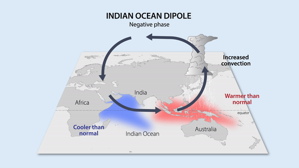
Figure 10: Graphical representation of the IOD during a negative phase where the rising branch is over South East Asia producing additional rains (Source: Earth Observatory of Singapore)
The Pacific Decadal Oscillation (PDO) is an El Niño-like phenomenon that occurs mostly in the North Pacific Ocean. During the warm, positive PDO phase, the surface water of the West Pacific along the Japanese archipelago and Chinese coast are cooler and the opposite during the cold, negative PDO. During this negative phase, increased rainfall is expected during the rainy season and lower temperatures in South East Asia.
The Interdecadal Pacific Oscillation (IPO) is similar to the PDO but covers a larger area of the Ocean. During the positive phase, the tropical Pacific waters are warmer, producing increased rainfall and strengthening the rainy monsoon in South East Asia. The negative phase can lead to conditions promoting droughts.
The Pacific Meridional Mode (PMM) is a climate phenomenon that is mostly characterised by a change in trade winds in the ocean. The PMM can have influence on rainfall in South East Asia but also on the behaviour of typhoons, producing intense cyclone seasons in its positive state.
All these phenomena (IOD, PDO, IPO and PMM) tend to be subordinate to the effects of ENSO in Northern Thailand (El Niño: dry / La Niña: wet). However, the Pacific Ocean oscillations modulate the intensity or the appearance of El Niño or La Niña and are therefore not completely independent climate features.

Table 1: Main large-scale atmospheric phenomena with effects in South East Asia.
Annual climate patterns
With everything presented before, the general meteorological variations and nuances in climate in South East Asia can be understood. However, the local monthly, weekly or daily weather in Chiang Mai and Northern Thailand is not a straightforward explanation and climatology can only explain seasonal changes, formation and abundance of rainstorms, dominant winds, etc. Going into further details is the world of meteorological models, advanced physics and supercomputer processing to take all parameters into account and produce forecasts and meaningful meteorological explanations for specific weather events.
Between mid-February and mid-May (with some variations), the Tibetan high pressure system brings the pre-monsoon conditions to Northern Thailand, along with dry air from the west. This period of the year is characterised by very dry conditions with rare clouds and weak winds carrying haze from Myanmar into Northern Thailand (see Air Pollution). As the season progresses, insolation increases, bringing increasingly higher temperatures and associated higher humidity until the start of the rainy season.
The mid-season regional conditions in March-April along with the sun position, the lack of turbulent winds, the presence of mountains & valleys and other factors, create a situation in which the highest temperatures are not found at ground level but around 800 meters above the surface. This is a meteorological situation called thermal inversion leading to colder, denser air trapped near the ground under a layer of warmer air in an overall static lower troposphere. This atmospheric situation is responsible for high levels of morning air pollution during the burning season (see Air Pollution).

Figure 11: Effect of temperature inversion and stable atmosphere during the hot season. Dark orange under the thermal inversion layer is the zone with haze conditions.
In April and May, while the atmosphere is increasingly more humid, the weather itself is still mostly dry but interrupted by frequent and sometimes violent rain storms. These events are caused by the WPSC-SAH high pressure system over southern China interacting with humid air coming from the south. As the air masses converge, it creates significant updraft producing large storms which are sometimes strong enough to generate damaging hail fall. Convective storms with strong shear winds can also produce landspouts, which are smaller version of mesocyclonic tornadoes and can create significant local damage.

Figure 12: Formation of rain storms and hail through the convergence of cold air (north) and warm, humid air (south) during the hot season.
Starting some time in June, the influence of the summer monsoon becomes dominant in Northern Thailand. While the Indian subcontinent is solely under the influence of the southern monsoon and coincides with the start of the rainy weather; in South East Asia, the situation can be a bit more ambiguous. Winds of the Indian monsoon arrives late May but precipitations can be mild, weakened by Myanmar mountains. When the East Asia summer monsoon reaches northern Thailand (sometime in June or even early July), the weather becomes significantly more rainy. The abundance of precipitation remains variable throughout the rainy season as it depends on other factors such as the position of the ITCZ.
From July to October, as the ITCZ has fully migrated in the summer monsoon system, extensive rain is brought from the coalescence of wet air masses from the Bay of Bengal and the South China Sea, particularly enhanced around the monsoon trough.
In addition to these precipitations, the other source of rain is tropical storms generated (or enhanced) in those seas. While tropical storms and cyclones from the Bay of Bengal capable of reaching Thailand are rare due to their North-East paths (1 per decade on average), typhoons from the Pacific, crossing through the Philippines and making landfall in Vietnam or Southern China are more prone to have a path that brings them over Thailand (2 per year on average). However, in both cases (Indian cyclones and Pacific typhoons), significant jet stream shear winds and mountainous topography make them quickly lose their kinetic energy over Laos or Myanmar and there is only a handful of tropical depressions that reach Northern Thailand with storm (non-cyclonic) winds (one every few year) and even less (1 in 100) with significant winds since record began. The main concern of these ex-cyclone tropical depression is the amount of humidity they bring over Thailand that can cause significant precipitation, often associated with flooding in the later months of the rainy season (see Flooding in Chiang Mai).

Figure 13. Monthly average of rainfall and frequency of tropical storms in the past few decades. Selected years are linked to major flood events in Chiang Mai (modified from Lim & Boochabun, 2012)